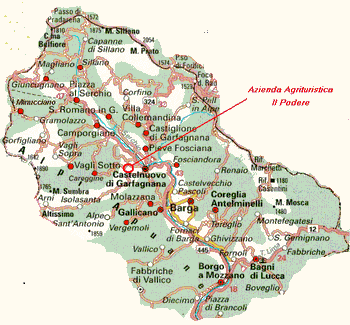
Historically with the word "Garfagnana" we mean the portion of the river Serchio Valley from the spring to Ponte di Campia, near Gallicano where, after a long narrowing, starts the Middle Valley; the communication difficulty with the main towns has always characterized Garfagnana untill some tens ago, when the SR 445 road was built, and has conditioned the history and development af the valley. Nowaday, with the word Garfagnana we mean the whole Serchio Valley almost untill Lucca.
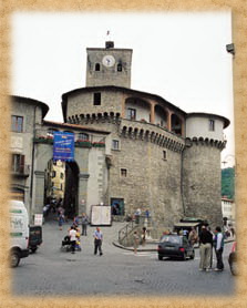
CASTELNUOVO DI GARFAGNANA ( 2 km away from us)
Castelnuovo di Garfagnana is the capital and the heart of the green Garfagnana that is situated in the northern part of the Serchio river valley, sorrounded between the spurs of the Apuan Alps and Appennins. It's 35 miles far from Lucca.
The earliest documents about Castelnuovo date back to 740 AD when it was a very small village; in 872 it was already defended by a castle and walls. During the Middle Age it was contended among the adjacient states, particularly Pisa and Lucca.
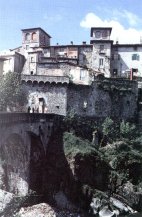
The original structure of the Castle dates back to the 11th century and then the fortress developed until in 14th century the ring of the defensive walls was enlarged. In 1430 the town submitted voluntarily itself to Este family and reached the highest point of its development. Castelnuovo became Provincial capital and some poets, as Ludovico Ariosto (1522-1525) and Fulvio Testi (1640-1642) were its governors. In 1850 by plebiscite it was annexed to Piedmont and in 1860 to the Kingdom of Italy. The Castle presents itself substantially renaissance being the result of continuous adequate restorations throught many centuries
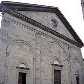
The Cathedral is located inside the walls and is dedicated to SS Peter and Paul. It dates back to the 10 century but the present building was rebuilt on an ancient Roman church at the beginning of the 16 century. During the Baroc some changes were made to the interior columned, preserving the austere facade; later many damages were done during the 2 nd WW. It still has valuable works as the Piece of S. Joseph, a Della Robbia school terracotta, a wooden cross of the 15 century called The Black Christ, a Ghirlandaio's painting Madonna with Saints, a Civitali's workshop marble frame and some paintings of the 17 century.
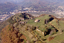
The Monte Alfonso Fortress is just out of the town, built at the end of the 15 century in opposition to Castiglione castle and to offer a safe shelter to citizens in case of enemy attack and siege. It was an Antonio Pasi architect project, with a boundary long more than 1 km and 7 bastions positioned asimmetricaly to adequate to the ground characteristics. Inside we can find 7 buildings designed to the troups. The main entrance has an archaded loggia over the walls. A very nice walkway is available all around the fortress.
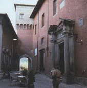
The Convent of S. Joseph was begun in 1632 and retains the funeral manument of the Duke Alfonso II of Modena who abandoned the throne to enter the Capucins order in 1628 and here died in 1644.
The Archeological Museum offers a widespread evidence from the Upper Serchio river Valley and on two periods that are particoularly well documented by important and peculiar finds: the Mesolitic and the Iron Age, showing finds of Ligurian Apuan people from the 4th century BC until the Romans occupation.
CASTIGLIONE DI GARFAGNANA (8 km)
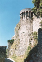
The history of Castiglione starts from a Roman camp during the war against the Ligurian Apuan people and develops in Longobardian and Franks ages. In the 100 AC the village already had the Castle as it is today, with the built up area all around, that was protected by walls and donjons in 1371. Castiglione was besieged several times from 1170 and so subjected to big destructions. The walls completely surround the ancient village where there are beautiful medieval works as S. Peter church, the donjons and the Castle with the embrasures for the crossbows. Near the village there is a medieval bridge close to the old mill, along the old road to the sanctuary of S. Pellegrino.
PARCO NATURALE DELL'ORECCHIELLA (18 km)
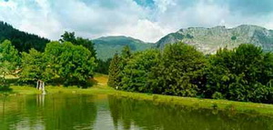
The park covers more than 50 sq.km. and reaches an altitude of 2054 above the sea level on top of the Tuscan - Emilian Appennine, from where we can be delighted with a breathtaking view of the Serchio river Valley and the upland of Campaiana. The roughness of the Pania di Corfino and the oneness of Sassorosso hill make a contrast with the gentleness of the upland with its fields and woods, full of springs and paludal areas.
wildlife of the park is substancial, from the golden eagle, to the hawk and several raptors and 130 birds species; moreover maofflons, deers, roes, boars and Appennine wolves. Several trecking, mountain biking and riding footpaths are available.
the mountainside of the Pania di Corfino we can find the Botanical Gardens where the autochthons floral species and plants and herbs used in traditional medicine and feeding are preserved.
SAN PELLEGRINO IN ALPE (30 km)
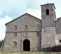
S. Pellegrino in Alpe is situated at 1525 m. above the sea level and it's the highest populated village in Appennins, located in an old strategic position along a pass between the the Northern Italy and the peninsula.The village maintains the ancient mountain characteristics, dominated by the medieval buildings of the Sanctuary and the ancient Hospital. The origins of the church are not sure and the first document dates back to 12 century; inside we can find the SS Pellegrino and Bianco marble urn.
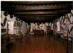
In the rooms of the ancient Hospital there is now an Ethnographical Museum of the local farming civilization and is one of the most important Italian collection. The museum consists of 14 large rooms, each of them dedicate to a particular rural working or living environment with descriptions of all the hundreds of tools displayed
ISOLA SANTA (15 km)
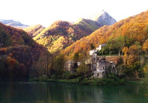
The origins of its name go to its geographical positionin the middle of the mountains and to the presence of an ancient Hospital for wayfarers who crossed the Apuan Alps. Documents about the village date back to 1200, but its origins are more ancient for sure. before the building of the dam, it was perhaps a little fortified village, over the ancient road, a watchpost in a very narrow valley, with a tower. The communications with the nearest towns and villages were very unconfortable and this condition lasted until some tens years ago, when the Cipollaio road was built to connect Garfagnana to Versilia. Later in 1949 the dam was built for hydroelectricity but it caused big problems to the village solidity and it became depopulated; now it is still an almost undamaged and unreal visitable village.
ALPI APUANE - ALTOPIANO DELLA VETRICIA - CAMPOCATINO - MONTE FORATO - ANTRO DEL CORCHIA (20 km)
The Apuan Alps are so called for their morphology and run along the Tyrrhenian coast line to an altitude of about 2000 m. above the sea level. The mountains have a calcareous origin and the particular pressures and stresses during the upheaval from the sea in Mesozoic created the marble deposits. Large examples of karsism caused by atmospheric agents and glaciations are still evident and make unique this area, protected by UNESCO and a Natural Park. In some deepest crevasses the neverending snow is still present.
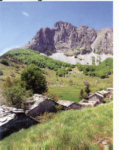
The upland of Vetricia is a beautiful area of the Apuan Alps, a wide rocky tableland between 1300-1500 m. above the sea level; rich of evident examples of karsism phenomena, frequent vertical fractures and erratic stones, it is also famous for its rock carvings. The Valley of Campocatino is one of the most suggestive areas of the Apuan Alps, from a naturalistic point of view. The ancient village was used by shepherd during their transhumance and is located in the centre of a glacial basin. Today the valley is an oasis of LIPU (Italian Birds Protection League) and crossed by a naturalistic footpath.
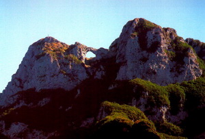
The Pierced Mountain is constitued by a twin picks, linked with a natural arch shaped by the atmospheric elements. From the top we can be delighted by a 360 degrees open view on the Apuan Alps picks, the Versilia coast, the sea and, on the opposite direction, on the Serchio river Valley.
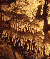
Plenty of rainfalls, together with the presence of soluble rocks, fostered the development of a karst pipes system characterised by wonderful and suggestive closed environments. These ones are rich in many-coloured ballstones.
LAGO DI VAGLI (15 km)
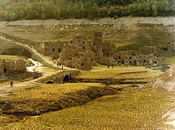
The first settlements in the area date back to Etrurians in the 4 century BC. In 20 century started the marble escavation near the village of Vagli, on the Garfagnanan slope of the Apuan Alps. In the fifties the level of the dam was heighten and the lake, the largest artificial lake in Europe, flooded some sorrounding villages and their inhabitants emigrated.
Every 10 years the lake is drained for maintenance and the coming out ancient built-up area of Fabbriche di Careggine is visitable.
GROTTA DEL VENTO - EREMO DI CALOMINI (20 km)
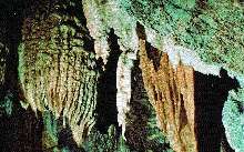
Situated at the centre of one of the wildest and ruggest areas of the Apuan Alps Natural Park, the Wind Cave offers visitors a comlete panorama of underground karst environments, which began 20 millions years ago and still continue today. It has been explored for 4.5 km and offers 3 different itineraries with a difference in altitude of 125 m. and a variety unique in Europe. The cave is divided in 3 sections, clearly diverse for morphological characteristics: the first is plain and full of calcareous accretions; the second starts with an abyss and is run by a subterranean river; the third presents large rooms and big vertical wells.
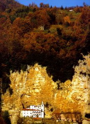
The Calomini Hermitage overtops the road to the Wind Cave, just under a big rock face. Documents concerning the church of S. Maria of Martyrs date back to 1361 and it was the place where a still exsisting Madonna's statuemade of willow was and is venerated. Probably, the Hermitage was already operational in 11 and 12 century, when the ascetic and contemplative life was brisk. The Sanctuary is mined into the rock and inside it's embellished with artistic stuccos representing the Blessed Virgin's symbols. Outside, the arcade is enriched with arches and columns in two superimposed lines, and, as a frame, it is all surrounded by the white-blue stone and the halm oak woods of the overhanging mountain.
The almost total silence and the big streams contribute to create an unique atmosphere.
ORRIDO DI BOTRI (30 km)
The Horrid of Botri is under environmental protection since 1971 and is a very narrow valley made by the water erosion. Due to the poor insolation of the cliffsides, the vegetation had an altimetric inversion; in other words, the plants that we can find there at the bottom usually live at higher altitude and viceversa. Moreover, on the always wet stones, we can find an insectivorous plant, the Pinguicola.
With the name Horrid of Botri are called two deep adjoining pits, run by the Mariana torrent. This spectacoular canyon, whose walls are vertical, was created by tectonic movements. The noise and paths of the water, the perpendicoular walls, the vegetation merge all together in a magic atmosphere where the sun light dims from the upland where the golden eagle lives.
CAVE DI MARMO DI CARRARA (30 km)
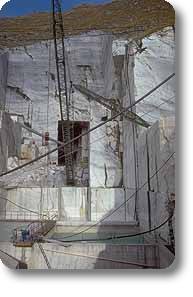
The marble mines are located on the Apuan Alps and were already worked by the Romans for art, architecture and common objects. In the past the blocks of marble were brought downstream with a particoular technic, called Lizzatura, using slaves and people condemned for major crimes. During the Renaissance also Michelangelo came in person to Carrara to choose the right stones for his works. Carrara's marble is famous all over the world for its variety of white and colors. The mines are visitable and represent a unique and charming environment.
BARGA (15 km)
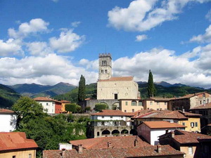
The origins of the town of Barga are lost in the history and date back to 2000 years ago; some documents state that in 9 century Barga was a longobardic feud with a castle, sorrounded by walls with 3 entrances. It was often contended between Lucca and Pisa in 12 and 13 century. From 1441 to 1859 remained under Florence control, then adhered to Piedmont and Kingdom of Italy.
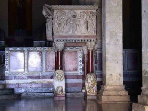
Its most important monuments are: the walls, dated at least back to the 9 century, the Royal Gate, the Cathedral whose earliest part dates back to 1000 and was later enlarged in 12, 13, 16 centuries, some Reinassance buildings and churchs, the theatre.
MORE
In the valley there are some high level turistic attractions on different points of view: naturalistic (Natural Parks of Apuan Alps, Orecchiella, Appennins, the Wind Cave, the Horrid of botri, the Marble Mines of Carrara, the lake of Vagli, some artificial lakes); artistic (Castelnuovo di Garfagnana, Castiglione di Garfagnana, Barga, many medieval villages and churches, some ghosts villages), entertainment (sporting facilities, golf, tennis, skiing, swimming school, football, trekking and mountain biking paths, riding school, river canoeing, paragliding, hang-gliding, hunting, fishing), amusement (discoes, bowling, pubs, bars, village festivals), cultural (Maggio representations, traditional events, carnival, artistic exhibitions, handcrafts) that make the valley and its extraordinary people a unique reality, projected in the present but well linked to its roots, giving to visitors a particular glimpse of a past that here seems still unchanged.
During summer/autumn we have a big production of high quality chestnuts and mushrooms and the area is famous for the boar hunting; the oldest cereal in the world, typical of this area, is also produced here: the spelt.
